Geoelectric Characterization of Hyporheic Exchange Flow in the Bedrock-Lined Streambed of East Fork Poplar Creek, Oak Ridge, Tennessee
Coupled electrical geophysics methods identify where water moves between groundwater and surface water.
April 28, 2023
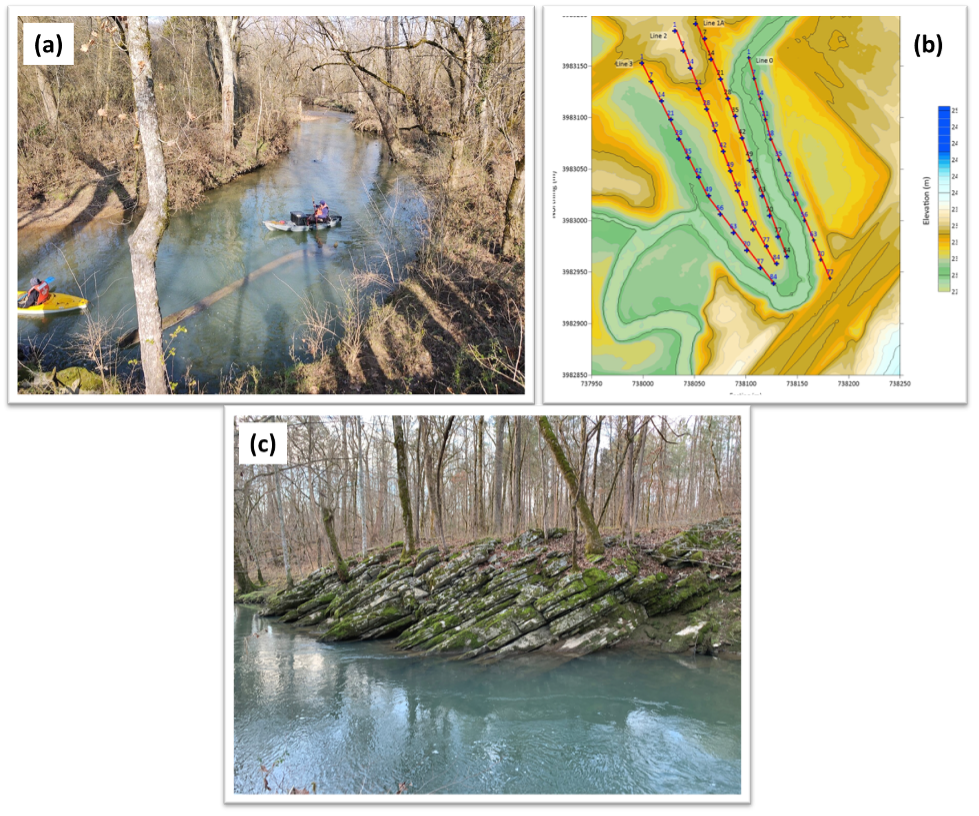
Waterborne self-potential (WaSP) logging (a) and land-based electrical resistivity tomography (ERT; b) were used together to identify locations where surface water–groundwater exchange was likely occurring along East Fork Poplar Creek in Oak Ridge, Tenn. Water movement between groundwater and surface water aligned with visible bedrock outcrops (c) and hidden underground fractures identified by ERT.
[Reprinted under a Creative Commons Attribution-NonCommercial-NoDerivatives 4.0 International License (CC BY-NC-ND 4.0) from Ikard, S. J., et al. "Geoelectric Characterization of Hyporheic Exchange Flow in the Bedrock-Lined Streambed of East Fork Poplar Creek, Oak Ridge, Tennessee." Geophysical Research Letters 50 (8), e2022GL102616 (2023). DOI:10.1029/2022GL102616.]
The Science
The zone around stream channels where groundwater mixes with surface water (the hyporheic zone) is highly active with the processing and transformation of carbon, nutrients, trace elements, and contaminants. Knowing how and where water moves between the surface and subsurface is essential to understanding the ecosystem services provided by streams and how they respond to changing climate and other anthropogenic activity (e.g., changing land cover). Previous work to identify the hyporheic zone has focused almost exclusively on streambeds with loose, unconsolidated sediment. Novel methods are needed to identify these water exchanges in bedrock-lined streams. A team of researchers applied two geoelectric survey methods along a 220-meter reach of the bedrock-lined East Fork Poplar Creek in East Tennessee. Natural electric fields were measured using waterborne self-potential arrays (WaSP), which identified where water moved between the groundwater and surface water in the stream channel. Artificial electric fields, which were generated by injecting electrical current into the ground, were used to create images of the electrical properties of subsurface materials using electrical resistivity tomography (ERT). ERT data revealed hidden information about subsurface structure and the hydrogeological setting. Both techniques are noninvasive and nondestructive. Results from the two methods were combined to map and characterize likely locations where water moves between the groundwater and surface water in the stream channel.
The Impact
Novel insights into groundwater–surface water exchange in bedrock-lined channels were gained by combining two geoelectric survey methods. These noninvasive and nondestructive techniques generate relatively high spatial resolution information over broad spatial scales. The results of this study enable mapping hyporheic exchange in bedrock-lined stream channels and may be able to capture exchange dynamics through time-lapse surveys.
Summary
Knowing where and how water moves between open stream channels and the surrounding subsurface is essential to understanding the role of streams in processing and transporting carbon, nutrients, trace elements, and contaminants. Nevertheless, current methods to study this water movement are not applicable to bedrock-lined channels. Therefore, this study applied two geoelectric survey techniques (WaSP and ERT) to map likely locations of groundwater–surface water exchange and interpreted them within their hydrogeological context. These locations aligned with visible bedrock outcrops and, importantly, with hidden underground fractures that were identified using ERT.
Principal Investigator
Scott Brooks
Oak Ridge National Laboratory
[email protected]
Program Manager
Paul Bayer
U.S. Department of Energy, Biological and Environmental Research (SC-33)
Environmental System Science
[email protected]
Funding
This work was supported by the U.S. Department of Energy’s (DOE) Minority-Serving Institution Partnership Program (MSIPP) managed by Savannah River National Laboratory under Battelle Savannah River Alliance, LLC, contract TOA 0000525176. This research was also sponsored by DOE’s Biological and Environmental Research (BER) Program’s Office of Science as part of the Watershed Dynamics and Evolution and Critical Interfaces Science Focus Areas at Oak Ridge National Laboratory, which is managed by UT-Battelle, LLC, for DOE under contract DE-AC05-00OR22725.
References
Ikard, S. J., et al. "Geoelectric Characterization of Hyporheic Exchange Flow in the Bedrock-Lined Streambed of East Fork Poplar Creek, Oak Ridge, Tennessee." Geophysical Research Letters 50 (8), e2022GL102616 (2023). https://doi.org/10.1029/2022GL102616.
Ikard, S. J., et al. "Waterborne Self-Potential Data, Surface-Water Temperature and Conductivity Logging Data, and Electric Resistivity Tomography Data Measured at East Fork Poplar Creek, Oak Ridge, Tennessee, January-March 2022." U.S. Geological Survey Data Release (2022). https://doi.org/10.5066/P9BAW75G.