WaDE: Watershed Dynamics and Evolution
Science Focus Area
Science Focus Area
Watersheds are complex systems that provide important ecosystem services. The freshwater resources supplied by streams and their surrounding watersheds are vital to human and environmental health and the global economy.
The economic and societal importance of streams and their surrounding watersheds—and their vulnerability to environmental stresses—is exemplified in the southeastern region of the United States.
Watersheds in the southeast are changing rapidly in response to anthropogenic forcings that include accelerated land use and land cover change and precipitation patterns. These rapid changes are expected to lead to dramatic shifts that fundamentally alter how watersheds function. Improving our understanding of watersheds in the southeastern region is critical to preserving the important societal and ecosystem services these systems provide for future generations.
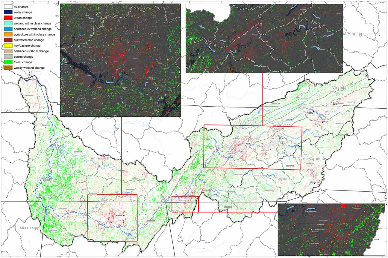
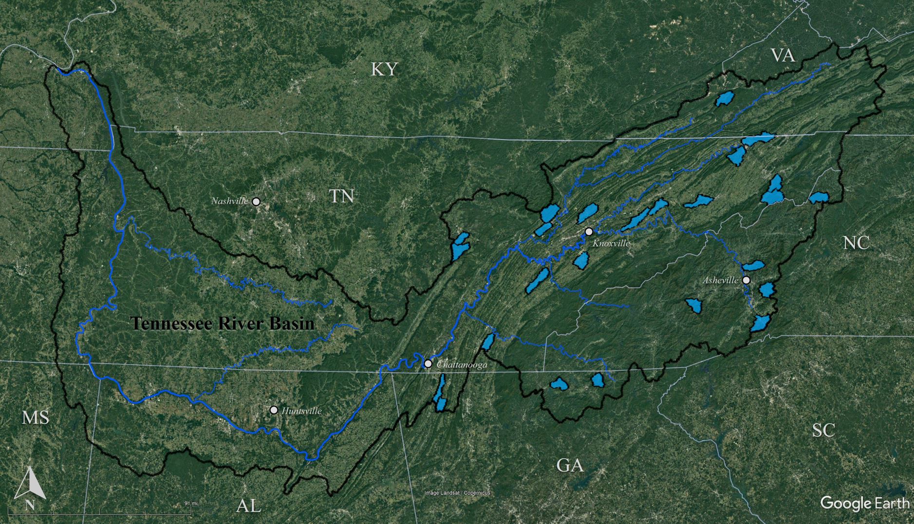
Tennessee River Basin Map. This map illustrates 30 x 30 m pixels that have experienced some form of change from 2001 to 2019, with the vast majority of pixels experiencing either forest change (green) or urbanization (red). Expanded images of three metro areas (Knoxville, Tenn.; Chattanooga, Tenn.; and Huntsville, Ala.) are also provided.
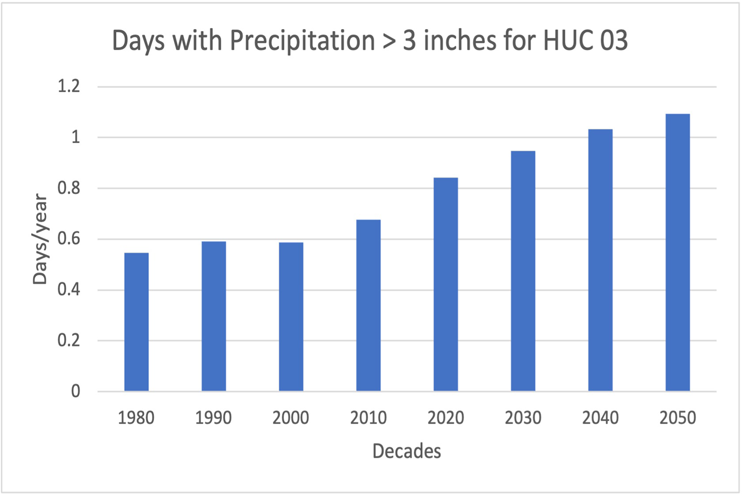
Historical data and future projections from six downscaled climate models for days per year with precipitation greater than 3 in (averaged over each decade) for Hydrologic Unit Code (HUC) 03, South Atlantic–Gulf States. Results show an increase in the number of days per year with greater than 3 in of rain.
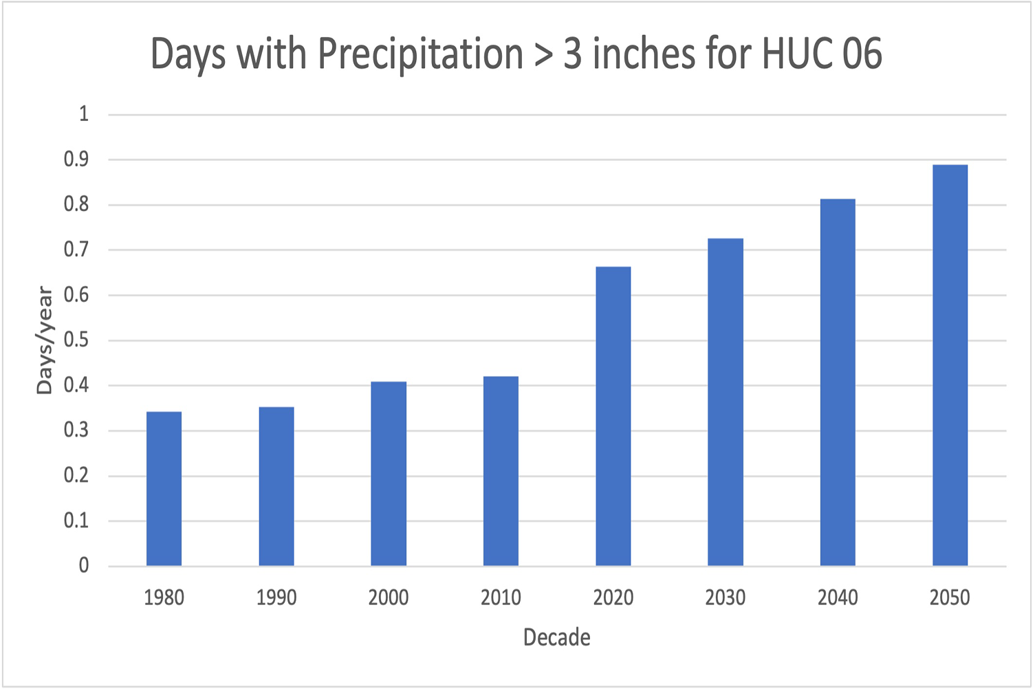
Historical data and future projections from six downscaled climate models for days per year with precipitation greater than 3 in (averaged over each decade) for Hydrologic Unit Code (HUC) 06, Tennessee River Basin. Results show an increase in the number of days per year with greater than 3 in of rain.
We do not understand if and how or at what scale land cover influences the generation and export of water and solutes from the landscape to the stream network and how this affects local and emergent hydro-biogeochemical function within the stream network.
We do not fully understand what controls upland–stream interactions and how these interactions vary under different hydrologic regimes and land covers.
We have an incomplete understanding of how measures of stream function, such as stream metabolism, integrate complex watershed properties that vary in space and time.
Existing observational networks are skewed to higher-order streams and underrepresent low- to mid-order streams.
The watershed science community has largely focused on end-member systems—forested, agricultural, and highly urbanized—and we currently lack sufficient observations in watersheds with heterogeneous land cover.
Model predictions of watershed function at basin- or continental United States–scales are uncertain because our mechanistic understanding of how key processes depend on land cover and hydrologic regimes is incomplete.
Over the next 9 years, Oak Ridge National Laboratory’s Watershed Dynamics and Evolution (WaDE) Science Focus Area (SFA) seeks to advance predictive understanding of how dominant processes controlling watershed hydro-biogeochemical function operate under a range of hydrologic regimes and vary along stream networks that drain heterogeneous land covers.
To advance watershed science, it is necessary to develop a systematic framework that explicitly links local physical–chemical–biological heterogeneity to larger spatial organization. Research efforts over the next 9 years will be on three watersheds, studied in succession, with the goal of systematically translating, applying, and refining the process understanding and modeling capabilities we gain from a specific watershed to increasingly disparate systems.
All three watersheds will be of similar mid-order size, with heterogeneous land cover, and located in areas experiencing rapid land cover change within the Tennessee River Basin.
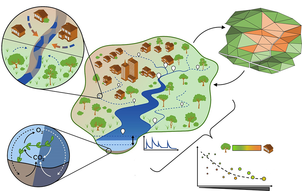
Research Foci. Conceptualization of 9-year research foci needed to support transferable understanding of watershed hydro-biogeochemical function within and across stream networks that drain heterogeneous land covers: non-perennial dynamics, contributions to stream metabolism, network-scale emergent behaviors, and responses to hydrologic events.
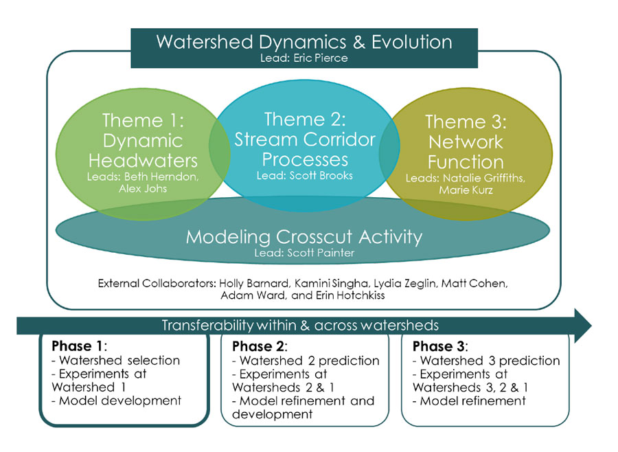
Science Focus Area (SFA) Organization. 9-year organization and progression of the Watershed Dynamics and Evolution SFA.
The WaDE SFA is organized around three integrated research themes and a crosscutting modeling activity that together create a multiscale, model–observation–experiment framework to enable hypothesis-driven research addressing the knowledge gaps.
Collectively, this framework will advance a deeper, predictive understanding of the hydro-biogeochemical processes and feedbacks that control solute mobilization and export from headwater catchments with heterogeneous land cover (Theme 1), resultant feedbacks between flow, solute concentrations, and stream function in stream corridors (Theme 2), and the emergent patterns in stream metabolism at network scales (Theme 3).
How do dynamic flow conditions in non-perennial streams control water and solute export from headwater catchments with varied land cover, and how do these processes influence downstream chemistry and metabolism?
What are the relative contributions of different stream compartments and microbial communities to stream metabolism, and how and why do these contributions vary in response to land cover, season, and hydrologic events?
How do the heterogeneity and resiliency of stream metabolism vary in space and time in relation to position along the stream network, land cover, and hydrologic events?
What is the minimum set of watershed attributes required to predict stream hydro-biogeochemical function at local to network scales? Do these attributes support transferability to other stream networks and hydrologic regimes?
The Tennessee River Basin, located in the southeastern United States, comprises a series of nested watersheds that encompass portions of seven states and support approximately 4.5 million people by supplying water resources for power generation, industry, recreation, agriculture, and human consumption. This support includes providing approximately 8% of the country’s total power via thermoelectric and hydroelectric plants (ranking fourth amongst water resource regions in overall power production). Maintaining these resources is critical to the economic future of individual states, regions, and the country. Yet watersheds in the Tennessee River Basin are vulnerable to the effects of changing land cover and hydrologic intensification.
Our research efforts are focused in mid-order watersheds (typically with stream order less than 4 and drainage area less than 100 km2) with heterogeneous land cover that are broadly representative of watersheds in the Tennessee River Basin.
Satellite map of WaDE's research locations.
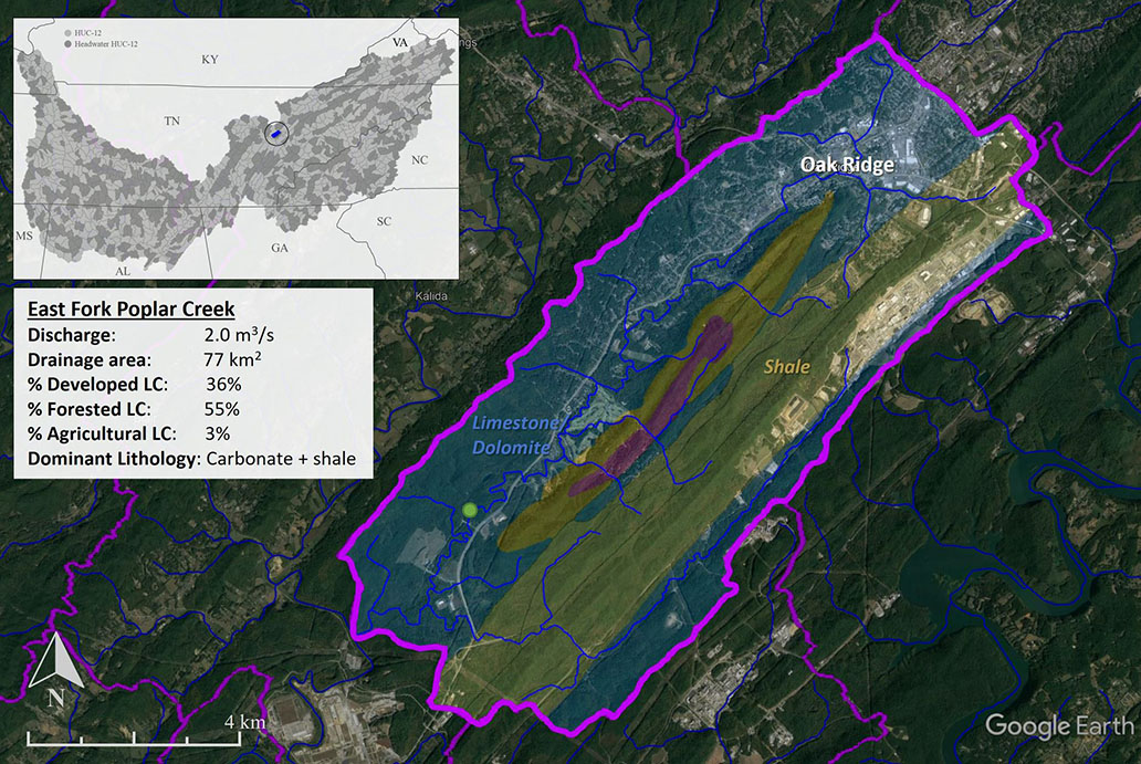
Satellite map of East Fork Poplar Creek in Oak Ridge, Tenn., one of 25 monitored watersheds.
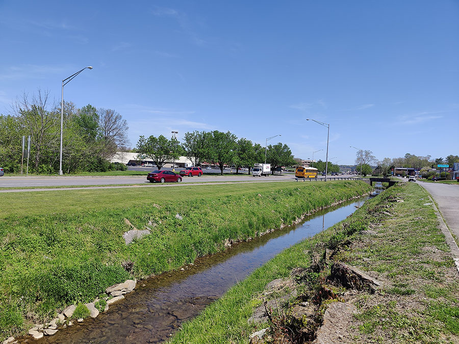
East Fork Poplar Creek in downtown Oak Ridge, Tenn.
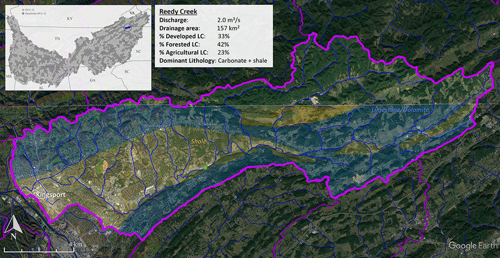
Satellite map of Reedy Creek in Kingsport, Tenn., one of 25 monitored watersheds.
Mud Creek in Hendersonville, N.C.